Geolocate

Manzanera topographic map

Click on the map to display elevation.

About this map

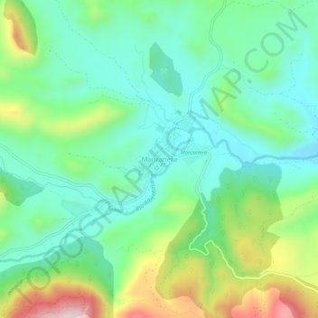
Name: Manzanera topographic map, elevation, terrain.

Location: Manzanera, Gúdar-Javalambre, Teruel, Aragón, España (40.03778 -0.85026 40.07778 -0.81026)

Average elevation: 1,072 m

Minimum elevation: 948 m

Maximum elevation: 1,361 m

Gear up for your next adventure:

🦯Trekking Poles - Reduced impact on joints for steep topographic climbs
🚲MTB Frame Bag - Carry tools and maps directly on your bicycle frame
🩹Moleskin Blister Pads - Direct protection for painful foot pressure points
🧤Thermal Hiking Gloves - Grip-enhanced gloves for cold-weather altitude trekking
🚲Heavy Duty Bike Lock - Secure your bike at the trailhead or during stops

As an Amazon Associate, this site earns from qualifying purchases at no extra cost to you.