
Make a donation
Gear up for your next adventure:
As an Amazon Associate, this site earns from qualifying purchases at no extra cost to you.
Vettweiß topographic map
Click on the map to display elevation.
Make a donation
Gear up for your next adventure:
As an Amazon Associate, this site earns from qualifying purchases at no extra cost to you.
About this map
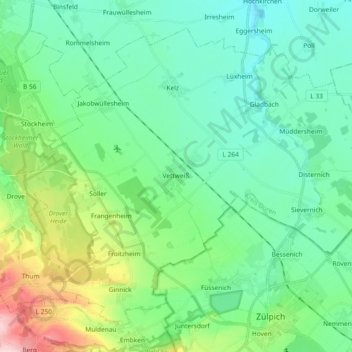
Name: Vettweiß topographic map, elevation, terrain.
Location: Vettweiß, Kreis Düren, Nordrhein-Westfalen, 52391, Deutschland (50.68941 6.51821 50.78800 6.70271)
Average elevation: 165 m
Minimum elevation: 113 m
Maximum elevation: 332 m
Make a donation
Gear up for your next adventure:
As an Amazon Associate, this site earns from qualifying purchases at no extra cost to you.
Other topographic maps
Click on a map to view its topography, its elevation and its terrain.
Make a donation
Gear up for your next adventure:
As an Amazon Associate, this site earns from qualifying purchases at no extra cost to you.
Gürzenich
Deutschland > Nordrhein-Westfalen > Kreis Düren > Düren
Vom 6. Oktober 1908 an wurde Gürzenich von der Straßenbahnlinie 3 der Dürener Kreisbahn (DKB) bedient. Die Strecke führte durch die heutige Valencienner Straße und die heutige Schillingsstraße und endete in Höhe der Kirche mit einem Umsetzgleis.
Average elevation: 134 m
Make a donation
Gear up for your next adventure:
As an Amazon Associate, this site earns from qualifying purchases at no extra cost to you.
Vossenack
Deutschland > Nordrhein-Westfalen > Kreis Düren > Hürtgenwald
Hürtgenwald liegt am Rande des Nationalparks Eifel und gehört zum deutsch-belgischen Naturpark Hohes Venn-Eifel und zur Rureifel. Der Ort liegt auf einem Höhenrücken oberhalb des Kalltales. Auf der Panoramastraße zwischen Schmidt und Vossenack, die durch das Kalltal führt, wurden früher Bergrennen mit…
Average elevation: 380 m