Geolocate

Kirkham topographic map

Click on the map to display elevation.

About this map
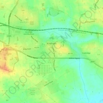
Name: Kirkham topographic map, elevation, terrain.

Location: Kirkham, Fylde, Lancashire, North West England, England, United Kingdom (53.76979 -2.91078 53.79063 -2.85681)

Average elevation: 22 m

Minimum elevation: 6 m

Maximum elevation: 42 m

Other topographic maps

Click on a map to view its topography, its elevation and its terrain.

Burnley

United Kingdom > England > Lancashire > Burnley > Burnley

Average elevation: 194 m

Coppull

United Kingdom > England > Lancashire > Chorley

The settlement has an Anglo Saxon name describing its topography derived from the Old English copp a hill top and hyll a hill. The township was variously recorded as Cophull and Cophulle in 1277, Copphull in 1351, Copthull in 1374 and Coppull from 1444.

Average elevation: 79 m

Brinscall

United Kingdom > England > Lancashire > Chorley

Average elevation: 195 m

Leyland

United Kingdom > England > Lancashire > South Ribble

Average elevation: 41 m

Trawden

United Kingdom > England > Lancashire > Borough of Pendle

Average elevation: 243 m

Galgate

United Kingdom > England > Lancashire > Lancaster > Galgate

Average elevation: 43 m

Gear up for your next adventure:

🥫Freeze-Dried Meals - Lightweight, high-calorie nutrition for multi-day treks
🧥Waterproof Pants - Keep dry during rainy hiking conditions
🛌Down Sleeping Bag - Superior warmth-to-weight ratio for cold nights
🔦LED Flashlight - Powerful and long-lasting flashlight for camping and emergencies
🌬️Windproof Camp Stove - Efficient cooking even on exposed mountain peaks

As an Amazon Associate, this site earns from qualifying purchases at no extra cost to you.