Geolocate

Macabato topographic map

Click on the map to display elevation.

About this map

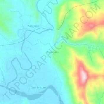
Name: Macabato topographic map, elevation, terrain.

Location: Macabato, Aringay, La Union, Ilocos Region, Philippines (16.39333 120.38270 16.43333 120.42270)

Average elevation: 100 m

Minimum elevation: 5 m

Maximum elevation: 404 m

Other topographic maps

Click on a map to view its topography, its elevation and its terrain.

Aringay River

Philippines > La Union > Aringay > Santa Lucia

Average elevation: 2 m

Gear up for your next adventure:

🚑Survival Whistle - Signal for help across long distances in mountains
🔦LED Flashlight - Powerful and long-lasting flashlight for camping and emergencies
🛌Insulated Sleeping Pad - Critical thermal barrier between you and the cold ground
🧦Hiking Liner Socks - Thin base layer to prevent friction and blisters
🥾Mountaineering Boots - Supportive boots for climbing and high-altitude hiking

As an Amazon Associate, this site earns from qualifying purchases at no extra cost to you.