Geolocate

Tambak Rejo topographic map

Click on the map to display elevation.

About this map

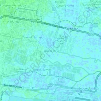
Name: Tambak Rejo topographic map, elevation, terrain.

Location: Tambak Rejo, Waru, Sidoarjo, East Java, 61253, Indonesia (-7.37602 112.76302 -7.33602 112.80302)

Average elevation: 2 m

Minimum elevation: -2 m

Maximum elevation: 5 m

Other topographic maps

Click on a map to view its topography, its elevation and its terrain.

Sedati

Indonesia > East Java > Sidoarjo

Average elevation: 1 m

Wonoayu

Indonesia > East Java > Sidoarjo

Average elevation: 10 m

Balongbendo

Indonesia > East Java > Sidoarjo

Average elevation: 21 m

Tarik

Indonesia > East Java > Sidoarjo

Average elevation: 18 m

Sukodono

Indonesia > East Java > Sidoarjo

Average elevation: 8 m

Candi

Indonesia > East Java > Sidoarjo

Average elevation: 3 m

Jabon

Indonesia > East Java > Sidoarjo

Average elevation: 4 m

Porong

Indonesia > East Java > Sidoarjo

Average elevation: 22 m

Gear up for your next adventure:

🥤Collapsible Travel Cup - Saves space and weight in your mess kit
💡Compact LED Flashlight - Powerful and portable flashlight for outdoor use
Camping Essentials - All-in-one gear for a comfortable camping trip
🧥Thermal Layer - Insulating layer for cold outdoor conditions
🥾Lightweight Hiking Boots - Boots for comfort and mobility on long hikes

As an Amazon Associate, this site earns from qualifying purchases at no extra cost to you.