Geolocate

Yuanyang County topographic map

Click on the map to display elevation.

About this map

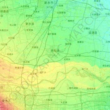
Name: Yuanyang County topographic map, elevation, terrain.

Location: Yuanyang County, Xinxiang City, Henan, China (34.87907 113.58328 35.18746 114.26949)

Average elevation: 81 m

Minimum elevation: 67 m

Maximum elevation: 115 m

Other topographic maps

Click on a map to view its topography, its elevation and its terrain.

Xinyang

China > Henan > Qianjin Subdistrict

Average elevation: 105 m

Kaifeng

China > Henan > Gulou District > Xiangguosi Subdistrict

Average elevation: 75 m

Daxingnanjiecun

China > Henan > Tangyin County

Average elevation: 85 m

Changtai

China > Henan

Average elevation: 84 m

Gear up for your next adventure:

🥾Lightweight Hiking Shoes - Comfortable shoes for day hikes
👟Leg Gaiters - Keep debris, mud, and snow out of your boots
🥾Waterproof Hiking Boots - Boots keeping your feet dry in wet conditions
🏕️Camping Hammock - Integrated protection for sleeping between trees
💧Hydration Bladder - Hands-free hydration solution for long treks

As an Amazon Associate, this site earns from qualifying purchases at no extra cost to you.