
Make a donation
Gear up for your next adventure:
As an Amazon Associate, this site earns from qualifying purchases at no extra cost to you.
Cacadu topographic map
Click on the map to display elevation.
Make a donation
Gear up for your next adventure:
As an Amazon Associate, this site earns from qualifying purchases at no extra cost to you.
About this map
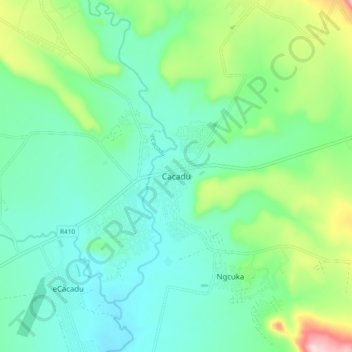
Name: Cacadu topographic map, elevation, terrain.
Average elevation: 1,059 m
Minimum elevation: 984 m
Maximum elevation: 1,281 m
Make a donation
Gear up for your next adventure:
As an Amazon Associate, this site earns from qualifying purchases at no extra cost to you.
Other topographic maps
Click on a map to view its topography, its elevation and its terrain.
Macubeni Dam
South Africa > Eastern Cape > Chris Hani District Municipality > Emalahleni Local Municipality
Average elevation: 1,347 m
Lubisi Dam
South Africa > Eastern Cape > Chris Hani District Municipality > Emalahleni Local Municipality
Average elevation: 1,052 m
Macubeni Dam
South Africa > Eastern Cape > Chris Hani District Municipality > Emalahleni Local Municipality
Average elevation: 1,347 m