Geolocate

Bagsi topographic map

Click on the map to display elevation.

About this map

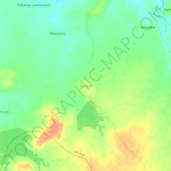
Name: Bagsi topographic map, elevation, terrain.

Location: Bagsi, Berasia Tahsil, Bhopal, Madhya Pradesh, 462120, India (23.65157 77.20419 23.69157 77.24419)

Average elevation: 456 m

Minimum elevation: 435 m

Maximum elevation: 482 m

Other topographic maps

Click on a map to view its topography, its elevation and its terrain.

Barli

India > Madhya Pradesh > Berasia Tahsil

Average elevation: 461 m

Gunga

India > Madhya Pradesh > Berasia Tahsil

Average elevation: 498 m

Bagsi

India > Madhya Pradesh > Berasia Tahsil > Bagsi

Average elevation: 458 m

Gear up for your next adventure:

🧰Emergency Multi-Tool - Compact multi-tool for outdoor survival
🕶️Polarized Sunglasses - Reduces glare from snow and water at high elevations
🧣Evaporative Cooling Towel - Beat the heat during intense summer climbs
🥾Trail Hiking Shoes - Durable shoes designed for rugged trails
🕶️Polarized Sunglasses - Protect your eyes with durable polarized lenses

As an Amazon Associate, this site earns from qualifying purchases at no extra cost to you.