
Make a donation
Gear up for your next adventure:
As an Amazon Associate, this site earns from qualifying purchases at no extra cost to you.
Laubuseschbach topographic map
Click on the map to display elevation.
Make a donation
Gear up for your next adventure:
As an Amazon Associate, this site earns from qualifying purchases at no extra cost to you.
Laubuseschbach
Durch den Ort fließt der Bleidenbach. Etwa 500 m südwestlich des Dorfes in Richtung Wolfenhausen, steht die Heideneiche auf der Passhöhe an der Kreisverkehr-Kreuzung. Die Gemarkungsfläche beträgt 7,73 Quadratkilometer, davon sind 2,09 Quadratkilometer Wald.
Make a donation
Gear up for your next adventure:
As an Amazon Associate, this site earns from qualifying purchases at no extra cost to you.
About this map
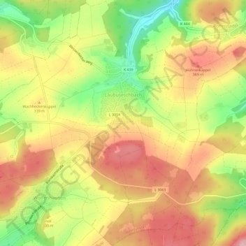
Name: Laubuseschbach topographic map, elevation, terrain.
Average elevation: 323 m
Minimum elevation: 227 m
Maximum elevation: 397 m
Make a donation
Gear up for your next adventure:
As an Amazon Associate, this site earns from qualifying purchases at no extra cost to you.