
Thank you for supporting this site ❤️
Make a donation
Make a donation
Gear up for your next adventure:
As an Amazon Associate, this site earns from qualifying purchases at no extra cost to you.
Correntini topographic map
Click on the map to display elevation.
Thank you for supporting this site ❤️
Make a donation
Make a donation
Gear up for your next adventure:
As an Amazon Associate, this site earns from qualifying purchases at no extra cost to you.
About this map
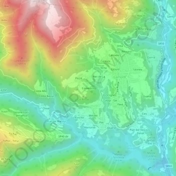
Name: Correntini topographic map, elevation, terrain.
Location: Correntini, Arina, Lamon, Belluno, Veneto, 32033, Italia (46.02461 11.71848 46.06461 11.75848)
Average elevation: 659 m
Minimum elevation: 341 m
Maximum elevation: 1,273 m
Thank you for supporting this site ❤️
Make a donation
Make a donation
Gear up for your next adventure:
As an Amazon Associate, this site earns from qualifying purchases at no extra cost to you.