Geolocate

Covatilla topographic map

Click on the map to display elevation.

About this map

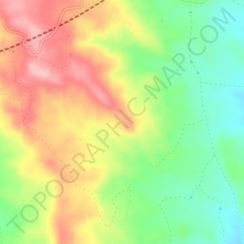
Name: Covatilla topographic map, elevation, terrain.

Location: Covatilla, Cuenca, Castilla-La Mancha, España (40.02054 -2.28048 40.04054 -2.26048)

Average elevation: 984 m

Minimum elevation: 908 m

Maximum elevation: 1,065 m

Other topographic maps

Click on a map to view its topography, its elevation and its terrain.

Rio Júcar

España > Castilla-La Mancha > Cuenca

Average elevation: 955 m

Embalse de La Toba

España > Castilla-La Mancha > Cuenca

Average elevation: 1,261 m

Gear up for your next adventure:

🥾Waterproof Hiking Boots - Boots keeping your feet dry in wet conditions
🧰Emergency Multi-Tool - Compact multi-tool for outdoor survival
🥾Hiking Leggings - Comfortable leggings for outdoor activities
🛌Down Sleeping Bag - Superior warmth-to-weight ratio for cold nights
🍽️Titanium Camping Spork - Ultralight and indestructible eating utensil

As an Amazon Associate, this site earns from qualifying purchases at no extra cost to you.