Geolocate

Saint-Adrien topographic map

Click on the map to display elevation.

About this map

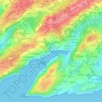
Name: Saint-Adrien topographic map, elevation, terrain.

Location: Saint-Adrien, Plougastel-Daoulas, Brest, Finistère, Bretagne, France métropolitaine, 29470, France (48.32190 -4.42179 48.36190 -4.38179)

Average elevation: 39 m

Minimum elevation: -2 m

Maximum elevation: 99 m

Other topographic maps

Click on a map to view its topography, its elevation and its terrain.

Gear up for your next adventure:

🩹Moleskin Blister Pads - Direct protection for painful foot pressure points
🪑Ultralight Camping Stool - Compact seating for rest stops during long hikes
🥤Collapsible Travel Cup - Saves space and weight in your mess kit
🥾Trail Hiking Shoes - Durable shoes designed for rugged trails
🥾Waterproof Trail Shoes - Shoes designed to handle wet terrain

As an Amazon Associate, this site earns from qualifying purchases at no extra cost to you.