
Make a donation
Gear up for your next adventure:
As an Amazon Associate, this site earns from qualifying purchases at no extra cost to you.
Courtney Lake topographic map
Click on the map to display elevation.
Make a donation
Gear up for your next adventure:
As an Amazon Associate, this site earns from qualifying purchases at no extra cost to you.
About this map
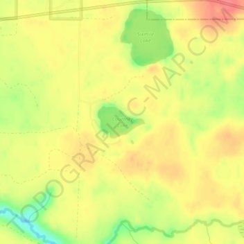
Name: Courtney Lake topographic map, elevation, terrain.
Average elevation: 358 m
Minimum elevation: 319 m
Maximum elevation: 382 m
Make a donation
Gear up for your next adventure:
As an Amazon Associate, this site earns from qualifying purchases at no extra cost to you.
Other topographic maps
Click on a map to view its topography, its elevation and its terrain.
Porcupine Mountains Wilderness State Park
United States > Michigan > Ontonagon County > Carp Lake Township
The mountains are subject to heavy lake-effect snow from Lake Superior. The relatively high elevation of the mountains and their proximity to the lake provide perfect conditions for lake-effect snow, but no official records are maintained anywhere in the mountains. The closest National Weather Service station…
Average elevation: 304 m
Make a donation
Gear up for your next adventure:
As an Amazon Associate, this site earns from qualifying purchases at no extra cost to you.
Porcupine Mountains Wilderness State Park
United States > Michigan > Ontonagon County
The mountains are subject to heavy lake-effect snow from Lake Superior. The relatively high elevation of the mountains and their proximity to the lake provide perfect conditions for lake-effect snow, but no official records are maintained anywhere in the mountains. The closest National Weather Service station…
Average elevation: 304 m
Make a donation
Gear up for your next adventure:
As an Amazon Associate, this site earns from qualifying purchases at no extra cost to you.
Make a donation
Gear up for your next adventure:
As an Amazon Associate, this site earns from qualifying purchases at no extra cost to you.