
Make a donation
Gear up for your next adventure:
As an Amazon Associate, this site earns from qualifying purchases at no extra cost to you.
Rübenach topographic map
Click on the map to display elevation.
Make a donation
Gear up for your next adventure:
As an Amazon Associate, this site earns from qualifying purchases at no extra cost to you.
About this map
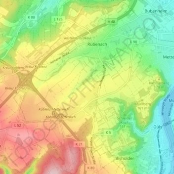
Name: Rübenach topographic map, elevation, terrain.
Location: Rübenach, Koblenz, Rheinland-Pfalz, 56072, Deutschland (50.32935 7.47825 50.38376 7.54314)
Average elevation: 171 m
Minimum elevation: 67 m
Maximum elevation: 300 m
Make a donation
Gear up for your next adventure:
As an Amazon Associate, this site earns from qualifying purchases at no extra cost to you.
Other topographic maps
Click on a map to view its topography, its elevation and its terrain.
Koblenz
Deutschland > Rheinland-Pfalz > Koblenz
Koblenz liegt laut Angabe des Bundesamtes für Kartographie und Geodäsie auf 73 m ü. NHN. Das Deutsche Eck liegt bei 64,7 m Höhe. Die höchste vollständig im Stadtgebiet gelegene Erhebung ist mit 382 m der Kühkopf im Stadtwald. Die höchste Stelle des Stadtgebietes mit 385 m befindet sich auf der Grenze…
Average elevation: 240 m
Make a donation
Gear up for your next adventure:
As an Amazon Associate, this site earns from qualifying purchases at no extra cost to you.