Geolocate

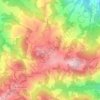
Sestola topographic map

Click on the map to display elevation.

About this map
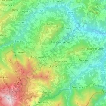
Name: Sestola topographic map, elevation, terrain.

Location: Sestola, Unione dei comuni del Frignano, Modena, Emilia-Romagna, 41029, Italy (44.19133 10.70061 44.29811 10.87085)

Average elevation: 848 m

Minimum elevation: 327 m

Maximum elevation: 2,153 m

Other topographic maps

Click on a map to view its topography, its elevation and its terrain.
Monte Cimone

Italy > Emilia-Romagna > Modena > Fiumalbo

The mountain has an elevation of 2,165 m and is also the highest point in the Emilia-Romagna region of Italy.

Average elevation: 1,759 m
Montombraro

Italy > Emilia-Romagna > Modena

Average elevation: 566 m

Monte della Torraccia

Italy > Emilia-Romagna > Modena > Montese

Average elevation: 923 m

Galleria

Italy > Emilia-Romagna > Modena > Campogalliano

Average elevation: 40 m

Barigazzo

Italy > Emilia-Romagna > Modena

Average elevation: 1,170 m

Pianorso

Italy > Emilia-Romagna > Modena

Average elevation: 846 m

Villanova

Italy > Emilia-Romagna > Modena > Modena

Average elevation: 32 m

Gear up for your next adventure:

🛁Quick-Dry Microfiber Towel - Space-saving towel that dries rapidly on the move
⛺Camping Tent - Weather-resistant tents suitable for 2 to 6 people
⛺Backpacking Tent - Lightweight tent for long-distance hiking trips
🧊Insulated Water Bottle - Keeps drinks cold in summer and prevents freezing in winter
🥘Camping Cookware Set - Compact nesting pots and pans for trail cooking

As an Amazon Associate, this site earns from qualifying purchases at no extra cost to you.