
Semirom topographic map
Interactive map
Click on the map to display elevation.
About this map
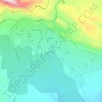
Name: Semirom topographic map, elevation, terrain.
Location: Semirom, بخش مرکزی سمیرم, شهرستان سمیرم, Ispahan, Iran (31.39034 51.54803 31.42430 51.60579)
Average elevation: 2,442 m
Minimum elevation: 2,246 m
Maximum elevation: 3,020 m
Other topographic maps
Click on a map to view its topography, its elevation and its terrain.
Zagros Mountains
Iran > Ispahan > شهرستان سمیرم > دهستان پادنا وسطی
Zagros Mountains, دهستان پادنا وسطی, بخش پادنا, شهرستان سمیرم, Ispahan, Iran
Average elevation: 3,846 m