
Chumbivilcas topographic map
Interactive map
Click on the map to display elevation.
About this map
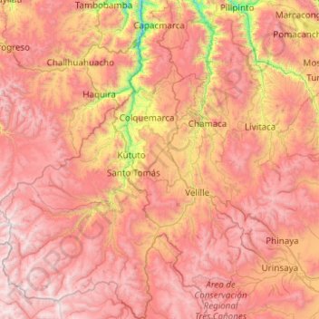
Name: Chumbivilcas topographic map, elevation, terrain.
Location: Chumbivilcas, Cusco, 08460, Perú (-14.88788 -72.50301 -13.93485 -71.51497)
Average elevation: 4,219 m
Minimum elevation: 2,792 m
Maximum elevation: 5,381 m
Other topographic maps
Click on a map to view its topography, its elevation and its terrain.