
Make a donation
Gear up for your next adventure:
As an Amazon Associate, this site earns from qualifying purchases at no extra cost to you.
Zachary topographic map
Click on the map to display elevation.
Make a donation
Gear up for your next adventure:
As an Amazon Associate, this site earns from qualifying purchases at no extra cost to you.
About this map
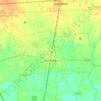
Name: Zachary topographic map, elevation, terrain.
Location: Zachary, East Baton Rouge Parish, Louisiana, United States (30.61149 -91.23277 30.70900 -91.08968)
Average elevation: 31 m
Minimum elevation: 17 m
Maximum elevation: 47 m
Make a donation
Gear up for your next adventure:
As an Amazon Associate, this site earns from qualifying purchases at no extra cost to you.
Other topographic maps
Click on a map to view its topography, its elevation and its terrain.
Nicholson Estates
United States > Louisiana > East Baton Rouge Parish > Baton Rouge
Average elevation: 11 m
Make a donation
Gear up for your next adventure:
As an Amazon Associate, this site earns from qualifying purchases at no extra cost to you.
Delmont Place
United States > Louisiana > East Baton Rouge Parish > Baton Rouge
Average elevation: 20 m
Carmen Terrace
United States > Louisiana > East Baton Rouge Parish > Baton Rouge
Average elevation: 16 m
Make a donation
Gear up for your next adventure:
As an Amazon Associate, this site earns from qualifying purchases at no extra cost to you.
Bell Fontaine
United States > Louisiana > East Baton Rouge Parish > Baton Rouge
Average elevation: 16 m
Marwede Place
United States > Louisiana > East Baton Rouge Parish > Baton Rouge
Average elevation: 17 m
Goodwood Estates
United States > Louisiana > East Baton Rouge Parish > Baton Rouge
Average elevation: 17 m
Make a donation
Gear up for your next adventure:
As an Amazon Associate, this site earns from qualifying purchases at no extra cost to you.
Sherwood Forest
United States > Louisiana > East Baton Rouge Parish > Baton Rouge
Average elevation: 16 m
Magnolia Heights
United States > Louisiana > East Baton Rouge Parish > Baton Rouge
Average elevation: 11 m
Make a donation
Gear up for your next adventure:
As an Amazon Associate, this site earns from qualifying purchases at no extra cost to you.
Monte Sano Trailer Park
United States > Louisiana > East Baton Rouge Parish > Baton Rouge > Monte Sano Trailer Park
Average elevation: 21 m
University Terrace
United States > Louisiana > East Baton Rouge Parish > Baton Rouge > University Terrace
Average elevation: 11 m
Sharon Hills
United States > Louisiana > East Baton Rouge Parish > Sharon Hills
Average elevation: 20 m
Make a donation
Gear up for your next adventure:
As an Amazon Associate, this site earns from qualifying purchases at no extra cost to you.