Geolocate

Guamote topographic map

Click on the map to display elevation.

About this map

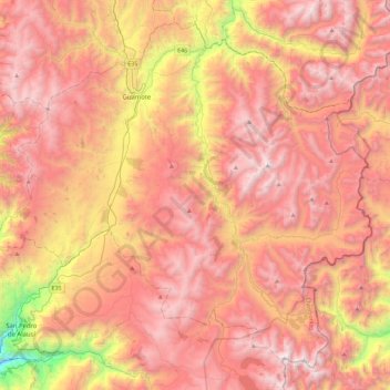
Name: Guamote topographic map, elevation, terrain.

Location: Guamote, Chimborazo, 060650, Ecuador (-2.24940 -78.89152 -1.84772 -78.43713)

Average elevation: 3,585 m

Minimum elevation: 2,042 m

Maximum elevation: 4,558 m

Other topographic maps

Click on a map to view its topography, its elevation and its terrain.

Coronado

Ecuador > Chimborazo > Chunchi > Chunchi

Average elevation: 3,928 m

Pueblo Viejo

Ecuador > Chimborazo > Alausí > Tixán

Average elevation: 2,825 m

Sibambe

Ecuador > Chimborazo > Sibambe > Sibambe

Average elevation: 2,444 m

Gear up for your next adventure:

🛰️Satellite Messenger - Emergency communication for areas with no cell service
🛁Quick-Dry Microfiber Towel - Space-saving towel that dries rapidly on the move
🥾Waterproof Hiking Shoes - Durable shoes for wet and rugged trails
Lightweight Camping Tent - Portable shelter optimized for Canadian backcountry camping
🧥Thermal Layer - Insulating layer for cold outdoor conditions

As an Amazon Associate, this site earns from qualifying purchases at no extra cost to you.