Geolocate

Nagwadi topographic map

Click on the map to display elevation.

About this map

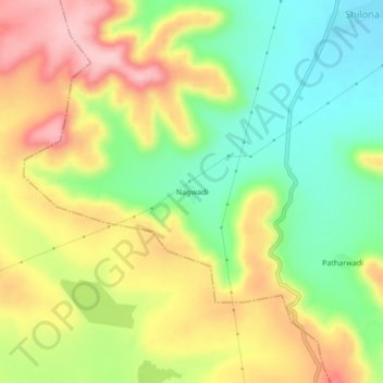
Name: Nagwadi topographic map, elevation, terrain.

Location: Nagwadi, Pusad, Yavatmal District, Maharashtra, India (19.71413 77.57219 19.75413 77.61219)

Average elevation: 427 m

Minimum elevation: 344 m

Maximum elevation: 522 m

Gear up for your next adventure:

🪑Ultralight Camping Stool - Compact seating for rest stops during long hikes
🔋Lithium AA Batteries - Long-lasting power that performs in extreme cold
🥾Mountain Hiking Boots - High-traction boots for rocky terrain
💧Reusable Water Bottle - Durable water bottles for hydration on trails
🧢Outdoor Visor - Breathable visor for sunny hikes

As an Amazon Associate, this site earns from qualifying purchases at no extra cost to you.