
San Francisco del Rincón topographic map
Interactive map
Click on the map to display elevation.
About this map
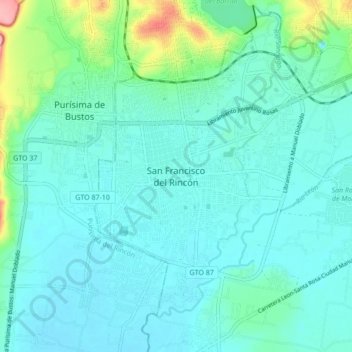
Name: San Francisco del Rincón topographic map, elevation, terrain.
Location: San Francisco del Rincón, Guanajuato, 36300, Mexico (20.97667 -101.89462 21.05667 -101.81462)
Average elevation: 1,767 m
Minimum elevation: 1,745 m
Maximum elevation: 1,874 m
The settlement was founded as San Francisco del Tule on January 21, 1607 by a group of families of the Purépecha and Hñähñu (Otomi) ethnicities. It was declared a villa (town) on September 6, 1865 and a city on March 27, 1867. It is located at 21°01′22″N 101°51′36″W / 21.02278°N 101.86000°W / 21.02278; -101.86000, at an approximate altitude of 1,721 meters.