Geolocate

Langenselbold topographic map

Click on the map to display elevation.

About this map

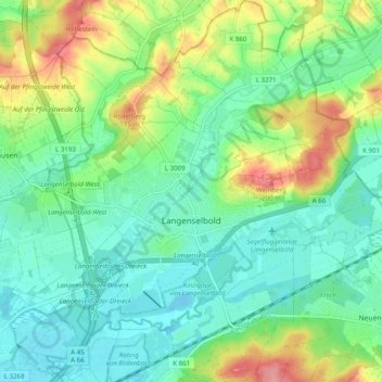
Name: Langenselbold topographic map, elevation, terrain.

Location: Langenselbold, Main-Kinzig-Kreis, Hesse, 63505, Germany (50.15131 9.00558 50.21452 9.09093)

Average elevation: 140 m

Minimum elevation: 110 m

Maximum elevation: 205 m

Other topographic maps

Click on a map to view its topography, its elevation and its terrain.

Ramholz

Germany > Hesse > Main-Kinzig-Kreis > Vollmerz

Average elevation: 373 m

Hanau

Germany > Hesse > Main-Kinzig-Kreis > Hanau

Average elevation: 110 m

Gear up for your next adventure:

🌬️Windproof Camp Stove - Efficient cooking even on exposed mountain peaks
🥾Mountain Hiking Boots - High-traction boots for rocky terrain
💧Filtered Water Bottle - Safe drinking water on the go
💡Portable Camping Lamp - Rechargeable lamp for campsite lighting
🧰Multitool Knife - Compact and versatile tool for outdoor use

As an Amazon Associate, this site earns from qualifying purchases at no extra cost to you.