Geolocate

Batam City topographic map

Click on the map to display elevation.

About this map

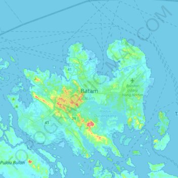
Name: Batam City topographic map, elevation, terrain.

Location: Batam City, Riau Islands, 29461, Indonesia (0.94610 103.87782 1.26610 104.19782)

Average elevation: 8 m

Minimum elevation: -2 m

Maximum elevation: 179 m

Other topographic maps

Click on a map to view its topography, its elevation and its terrain.

Pulau Galang

Indonesia > Riau Islands > Batam City

Average elevation: 9 m

Gear up for your next adventure:

🛰️Satellite Messenger - Emergency communication for areas with no cell service
🧢Hiking Hat - Sun-protective and breathable hats for long treks
🚑Survival Whistle - Signal for help across long distances in mountains
🧶550 Survival Paracord - Versatile utility cord for emergency repairs and rigging
🥾Waterproof Hiking Boots - Boots keeping your feet dry in wet conditions

As an Amazon Associate, this site earns from qualifying purchases at no extra cost to you.