Geolocate

Shanakiel topographic map

Click on the map to display elevation.

About this map

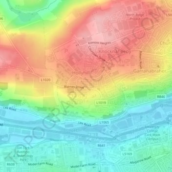
Name: Shanakiel topographic map, elevation, terrain.

Location: Shanakiel, Cork, County Cork, Munster, Ireland (51.89415 -8.52058 51.90811 -8.49869)

Average elevation: 67 m

Minimum elevation: 3 m

Maximum elevation: 143 m

Other topographic maps

Click on a map to view its topography, its elevation and its terrain.

Cork

Ireland > County Cork > Cork

Average elevation: 94 m

Tramore Valley Park

Ireland > County Cork > Cork

Average elevation: 28 m

Upper Glanmire Bridge

Ireland > County Cork > Cork

Average elevation: 90 m

Fair Hill

Ireland > County Cork > Cork

Average elevation: 68 m

Ballincollig Regional Park

Ireland > County Cork > Cork

Average elevation: 55 m

Ballincollig

Ireland > County Cork > Cork

Average elevation: 62 m

Beaumont Park

Ireland > County Cork > Cork

Average elevation: 12 m

River Lee (North Channel)

Ireland > County Cork > Cork

Average elevation: 49 m

Kerry Pike

Ireland > County Cork > Cork

Average elevation: 55 m

Stone Beach

Ireland > County Cork > Cork

Average elevation: 47 m

River Lee (North Channel)

Ireland > County Cork > Cork

Average elevation: 32 m

Gear up for your next adventure:

🥾Hiking Gaiters - Protect legs and shoes from mud, snow, and debris
Family Camping Tent - Spacious tent suitable for family camping trips
🥤Collapsible Travel Cup - Saves space and weight in your mess kit
🛁Quick-Dry Microfiber Towel - Space-saving towel that dries rapidly on the move
🧭GPS Handheld Device - Reliable GPS navigation for outdoor adventures

As an Amazon Associate, this site earns from qualifying purchases at no extra cost to you.