
Casteltermini topographic map
Interactive map
Click on the map to display elevation.
About this map
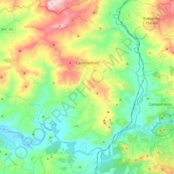
Name: Casteltermini topographic map, elevation, terrain.
Location: Casteltermini, Agrigente, Sicile, 92025, Italie (37.47086 13.53405 37.57522 13.69533)
Average elevation: 375 m
Minimum elevation: 88 m
Maximum elevation: 961 m
Other topographic maps
Click on a map to view its topography, its elevation and its terrain.
Santo Stefano Quisquina
Santo Stefano Quisquina, Agrigente, Sicile, 92020, Italie
Average elevation: 642 m