Geolocate

Synkivka topographic map

Click on the map to display elevation.

About this map

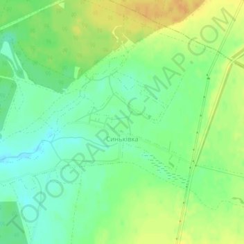
Name: Synkivka topographic map, elevation, terrain.

Location: Synkivka, Петропавлівська сільська громада, Kupiansk Raion, Kharkiv Oblast, Ukraine (49.75729 37.68182 49.77218 37.71581)

Average elevation: 101 m

Minimum elevation: 87 m

Maximum elevation: 117 m

Other topographic maps

Click on a map to view its topography, its elevation and its terrain.

Kostiantynivka

Ukraine > Kharkiv Oblast

Average elevation: 142 m

Andriivka

Ukraine > Kharkiv Oblast

Average elevation: 94 m

Donets

Ukraine > Kharkiv Oblast

Average elevation: 96 m

Kostiantynivka

Ukraine > Kharkiv Oblast

Average elevation: 142 m

Andriivka

Ukraine > Kharkiv Oblast

Average elevation: 94 m

Andriivka

Ukraine > Kharkiv Oblast

Average elevation: 94 m

Donets

Ukraine > Kharkiv Oblast

The Donets originates on the Central Russian Upland, near Podolkhi village, Prokhorovka area, north of Belgorod, at an elevation of 200 m (660 ft) above sea level. Its basin contains over 3000 rivers, of which 425 are longer than 10 km (6.2 mi) and 11 are longer than 100 km (62 mi); 1011 of those rivers…

Average elevation: 128 m

Andriivka

Ukraine > Kharkiv Oblast

Average elevation: 94 m

Levkivka

Ukraine > Kharkiv Oblast

Average elevation: 101 m

Sakhnovshchyna

Ukraine > Kharkiv Oblast

Average elevation: 159 m

Gear up for your next adventure:

💧Reusable Water Bottle - Durable water bottles for hydration on trails
🧭GPS Outdoor Watch - Smart watch for navigation and fitness tracking in nature
💧Hydration Pack - Hands-free hydration system for long hikes
🏕️Camping Hammock - Integrated protection for sleeping between trees
🥾Trekking Poles - Adjustable trekking poles to reduce knee stress and improve stability

As an Amazon Associate, this site earns from qualifying purchases at no extra cost to you.