
Make a donation
Gear up for your next adventure:
As an Amazon Associate, this site earns from qualifying purchases at no extra cost to you.
Lago Villarrica topographic map
Click on the map to display elevation.
Make a donation
Gear up for your next adventure:
As an Amazon Associate, this site earns from qualifying purchases at no extra cost to you.
About this map
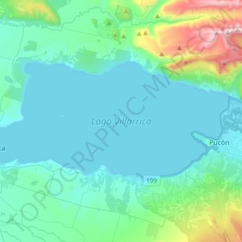
Name: Lago Villarrica topographic map, elevation, terrain.
Average elevation: 380 m
Minimum elevation: 208 m
Maximum elevation: 1,383 m
Make a donation
Gear up for your next adventure:
As an Amazon Associate, this site earns from qualifying purchases at no extra cost to you.
Other topographic maps
Click on a map to view its topography, its elevation and its terrain.
Volcán Villarrica
Chile > Región de la Araucanía > Provincia de Cautín > Villarrica
Entre los mayores centros poblados, Coñaripe (debido a la topografía del terreno)
Average elevation: 2,316 m
Plaza Río Cóndor
Chile > Región de la Araucanía > Provincia de Cautín > Villarrica
Average elevation: 301 m
Comunidad José Antilef
Chile > Región de la Araucanía > Provincia de Cautín > Villarrica
Average elevation: 227 m
Make a donation
Gear up for your next adventure:
As an Amazon Associate, this site earns from qualifying purchases at no extra cost to you.
Mirador Pinohuacho
Chile > Región de la Araucanía > Provincia de Cautín > Villarrica
Average elevation: 762 m
Volcán Villarrica
Chile > Región de la Araucanía > Provincia de Cautín > Villarrica
Entre los mayores centros poblados, Coñaripe (debido a la topografía del terreno)
Average elevation: 2,316 m