
Make a donation
Gear up for your next adventure:
As an Amazon Associate, this site earns from qualifying purchases at no extra cost to you.
Bonn-Zentrum topographic map
Click on the map to display elevation.
Make a donation
Gear up for your next adventure:
As an Amazon Associate, this site earns from qualifying purchases at no extra cost to you.
About this map
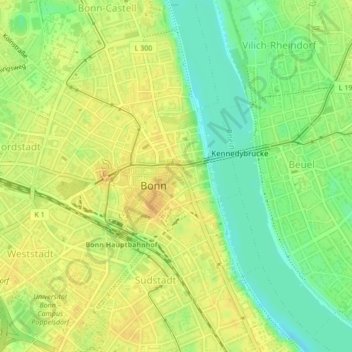
Name: Bonn-Zentrum topographic map, elevation, terrain.
Average elevation: 59 m
Minimum elevation: 42 m
Maximum elevation: 70 m
Make a donation
Gear up for your next adventure:
As an Amazon Associate, this site earns from qualifying purchases at no extra cost to you.
Other topographic maps
Click on a map to view its topography, its elevation and its terrain.
Bonn
Deutschland > Nordrhein-Westfalen > Bonn
Bonn hat seinen geografischen Mittelpunkt am Bundeskanzlerplatz, der sich im Ortsteil Gronau befindet. Die geografische Lage des Platzes ist 50° 43′ 8,8″ N, 7° 7′ 3,3″ O50.7191138888897.1175722222222. Die Bonner Innenstadt, die nicht zum Rhein hin ausgerichtet ist, liegt auf einer Höhe von 56 m bis 61 m ü. NHN.
Average elevation: 138 m
Make a donation
Gear up for your next adventure:
As an Amazon Associate, this site earns from qualifying purchases at no extra cost to you.