
Corno Gries / Grieshorn topographic map
Interactive map
Click on the map to display elevation.
About this map
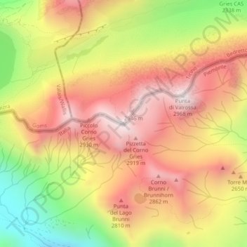
Name: Corno Gries / Grieshorn topographic map, elevation, terrain.
Average elevation: 2,557 m
Minimum elevation: 2,044 m
Maximum elevation: 2,940 m
Other topographic maps
Click on a map to view its topography, its elevation and its terrain.
Capanna Corno Gries CAS
Suisse > Tessin > District de Léventine > Bedretto
Capanna Corno Gries CAS, gta, Corno, Bedretto, Circolo di Airolo, District de Léventine, Tessin, 6781, Suisse
Average elevation: 2,417 m
All'Acqua
Suisse > Tessin > District de Léventine > Bedretto
All'Acqua, Bedretto, Circolo di Airolo, District de Léventine, Tessin, 6781, Suisse
Average elevation: 2,033 m