
Namiquipa topographic map
Interactive map
Click on the map to display elevation.
About this map
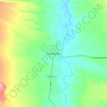
Name: Namiquipa topographic map, elevation, terrain.
Location: Namiquipa, Chihuahua, México (29.21069 -107.45507 29.29069 -107.37507)
Average elevation: 1,871 m
Minimum elevation: 1,810 m
Maximum elevation: 2,013 m
Other topographic maps
Click on a map to view its topography, its elevation and its terrain.
El Terrero
México > Chihuahua > Namiquipa
El Terrero, Namiquipa, Chihuahua, México
Average elevation: 1,867 m