Geolocate

Krapina topographic map

Click on the map to display elevation.

About this map

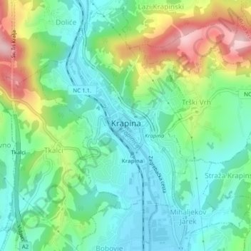
Name: Krapina topographic map, elevation, terrain.

Location: Krapina, Grad Krapina, Krapina-Zagorje County, 49000, Croatia (46.14989 15.85762 46.17512 15.88098)

Average elevation: 252 m

Minimum elevation: 172 m

Maximum elevation: 429 m

Other topographic maps

Click on a map to view its topography, its elevation and its terrain.

Pregrada

Croatia > Krapina-Zagorje County

Average elevation: 266 m

Gear up for your next adventure:

💡LED Camping Lantern - Illuminate your campsite with long-lasting lanterns
Backpacking Tent - Lightweight tent for long-distance hiking trips
🥾Hiking Gaiters - Protect legs and shoes from mud, snow, and debris
🥽Outdoor Goggles - Protective eyewear for outdoor activities
🥾Trekking Poles - Adjustable trekking poles to reduce knee stress and improve stability

As an Amazon Associate, this site earns from qualifying purchases at no extra cost to you.