Geolocate

Splendora topographic map

Click on the map to display elevation.

About this map

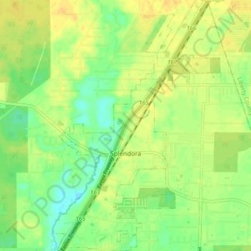
Name: Splendora topographic map, elevation, terrain.

Location: Splendora, Montgomery County, Texas, 77372, United States (30.20831 -95.18246 30.27156 -95.13354)

Average elevation: 37 m

Minimum elevation: 24 m

Maximum elevation: 47 m

Other topographic maps

Click on a map to view its topography, its elevation and its terrain.

New Caney

United States > Texas > Montgomery County

Average elevation: 30 m

Porter

United States > Texas > Montgomery County

Average elevation: 30 m

Mount Zion

United States > Texas > Montgomery County

Average elevation: 88 m

Bobville

United States > Texas > Montgomery County

Average elevation: 75 m

Lakeland

United States > Texas > Montgomery County

Average elevation: 44 m

Conroe

United States > Texas > Montgomery County > Conroe > Conroe

Average elevation: 60 m

Security

United States > Texas > Montgomery County

Average elevation: 53 m

Porter

United States > Texas > Montgomery County

Average elevation: 30 m

New Caney

United States > Texas > Montgomery County

Average elevation: 30 m

Gear up for your next adventure:

🥾Trail Running Shoes - Lightweight and durable shoes for trail running
💧Collapsible Water Bottle - Space-saving water bottle for outdoor activities
🧢Outdoor Visor - Breathable visor for sunny hikes
🩹Moleskin Blister Pads - Direct protection for painful foot pressure points
🧦Hiking Liner Socks - Thin base layer to prevent friction and blisters

As an Amazon Associate, this site earns from qualifying purchases at no extra cost to you.