
Thank you for supporting this site ❤️
Make a donation
Make a donation
Gear up for your next adventure:
As an Amazon Associate, this site earns from qualifying purchases at no extra cost to you.
兜布丸山 topographic map
Click on the map to display elevation.
Thank you for supporting this site ❤️
Make a donation
Make a donation
Gear up for your next adventure:
As an Amazon Associate, this site earns from qualifying purchases at no extra cost to you.
About this map
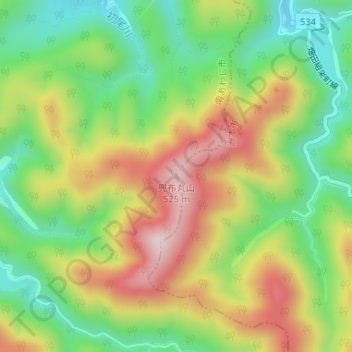
Name: 兜布丸山 topographic map, elevation, terrain.
Location: 兜布丸山, Sumoto, Hyogo Prefecture, Japan (34.27743 134.83721 34.27753 134.83731)
Average elevation: 297 m
Minimum elevation: 121 m
Maximum elevation: 519 m
Thank you for supporting this site ❤️
Make a donation
Make a donation
Gear up for your next adventure:
As an Amazon Associate, this site earns from qualifying purchases at no extra cost to you.