
Dunaszekcső topographic map
Interactive map
Click on the map to display elevation.
About this map
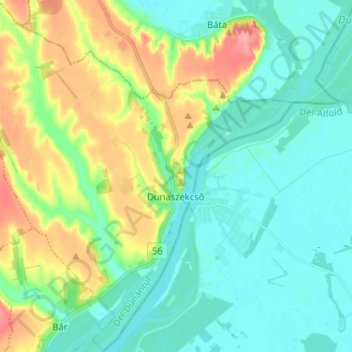
Name: Dunaszekcső topographic map, elevation, terrain.
Average elevation: 109 m
Minimum elevation: 82 m
Maximum elevation: 174 m
Other topographic maps
Click on a map to view its topography, its elevation and its terrain.
Villány
Villány, Siklósi járás, Baranya vármegye, Transdanubio Meridional, Transdanubia, 7773, Hungría
Average elevation: 124 m