Geolocate

Independence topographic map

Click on the map to display elevation.

Independence

Independence is a census-designated place in Inyo County, California. Independence is located 41 miles (66 km) south-southeast of Bishop, at an elevation of 3930 feet (1198 m). It is the county seat of Inyo County, California. The population of this census-designated place was 669 at the 2010 census, up from 574 at the 2000 census.

Wikipedia (CC-BY-SA 3.0)

About this map

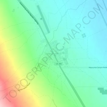
Name: Independence topographic map, elevation, terrain.

Location: Independence, Inyo County, California, 93526, United States (36.78251 -118.21972 36.82251 -118.17972)

Average elevation: 1,210 m

Minimum elevation: 1,154 m

Maximum elevation: 1,353 m

Other topographic maps

Click on a map to view its topography, its elevation and its terrain.

Darwin

United States > California > Inyo County

Darwin is an unincorporated mining community in Inyo County, California, United States. It is located 22 miles (35 km) southeast of Keeler, at an elevation of 4,790 ft (1,460 m). The population was 43 at the 2010 census, down from 54 at the 2000 census.

Average elevation: 1,484 m

Trona

United States > California > Inyo County

Average elevation: 569 m

Cartago

United States > California > Inyo County

Cartago (Spanish for "Carthage") is a census-designated place in Inyo County, California, United States. Cartago is located on the west side of Owens Lake 3 miles (4.8 km) north-northwest of Olancha, at an elevation of 3629 feet (1106 m). The population was 92 at the 2010 census, down from 109 at the 2000…

Average elevation: 1,152 m

Round Valley

United States > California > Inyo County

Round Valley is a census-designated place (CDP) in Inyo County, California, United States. Round Valley is located 7.5 miles (12 km) northeast of Mount Tom, at an elevation of 4692 feet (1430 m). The population was 435 at the 2010 census, up from 278 at the 2000 census.

Average elevation: 1,491 m

Pearsonville

United States > California > Inyo County

Average elevation: 796 m

Owens Valley

United States > California > Inyo County

Average elevation: 2,090 m

Gem Lakes

United States > California > Inyo County

Average elevation: 3,481 m

Upper Lamarck Lake

United States > California > Inyo County

Average elevation: 3,457 m

Olancha

United States > California > Inyo County

Olancha (Timbisha: Pakwa' si) is a census designated place in Inyo County of the U.S. state of California. Olancha is located on U.S. Route 395 in California, 37 miles (60 km) south-southeast of Independence, at an elevation of 3658 feet (1115 m). As of the 2010 census, the population was 192, up from 134 at…

Average elevation: 1,200 m

Racetrack Playa

United States > California > Inyo County

Average elevation: 1,219 m

Big Pine Creek

United States > California > Inyo County > Big Pine

Average elevation: 1,210 m

Palisade Glacier

United States > California > Inyo County

Average elevation: 3,839 m

West Bishop

United States > California > Inyo County

Average elevation: 1,481 m

Gear up for your next adventure:

🛏️Sleeping Bag - Warm and compact sleeping bags for outdoor camping
💧Collapsible Water Bottle - Space-saving water bottle for outdoor activities
🧤Rechargeable Heated Gloves - Extreme warmth for Canadian winter expeditions
🧤Thermal Hiking Gloves - Grip-enhanced gloves for cold-weather altitude trekking
Camping Tent - Weather-resistant tents suitable for 2 to 6 people

As an Amazon Associate, this site earns from qualifying purchases at no extra cost to you.