
Make a donation
Gear up for your next adventure:
As an Amazon Associate, this site earns from qualifying purchases at no extra cost to you.
Zone 14 Perungudi topographic map
Click on the map to display elevation.
Make a donation
Gear up for your next adventure:
As an Amazon Associate, this site earns from qualifying purchases at no extra cost to you.
Zone 14 Perungudi
Perungudi is located at 12°58′N 80°15′E / 12.97°N 80.25°E / 12.97; 80.25. It has an average elevation of 9 metres (29 feet).
Make a donation
Gear up for your next adventure:
As an Amazon Associate, this site earns from qualifying purchases at no extra cost to you.
About this map
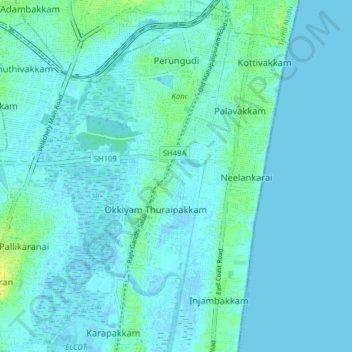
Name: Zone 14 Perungudi topographic map, elevation, terrain.
Location: Zone 14 Perungudi, Sholinganallur, Chennai, Tamil Nadu, India (12.90931 80.18769 12.98236 80.26631)
Average elevation: 3 m
Minimum elevation: -4 m
Maximum elevation: 17 m
Make a donation
Gear up for your next adventure:
As an Amazon Associate, this site earns from qualifying purchases at no extra cost to you.
Other topographic maps
Click on a map to view its topography, its elevation and its terrain.
Make a donation
Gear up for your next adventure:
As an Amazon Associate, this site earns from qualifying purchases at no extra cost to you.
Make a donation
Gear up for your next adventure:
As an Amazon Associate, this site earns from qualifying purchases at no extra cost to you.