
Make a donation
Gear up for your next adventure:
As an Amazon Associate, this site earns from qualifying purchases at no extra cost to you.
Nikolausberg topographic map
Click on the map to display elevation.
Make a donation
Gear up for your next adventure:
As an Amazon Associate, this site earns from qualifying purchases at no extra cost to you.
Nikolausberg
Nikolausberg ist ein nordöstlicher Stadtteil der Universitätsstadt Göttingen. Er ist ebenso wie der benachbarte Stadtteil Roringen mit 280 bis 350 m ü. NN bis zu 200 m höher als die Göttinger Innenstadt gelegen. Während 1896 im Ort 288 Einwohner verzeichnet waren, hat sich deren Zahl seit dem Bau der Wasserleitung in den 1950er-Jahren stark gesteigert und betrug 2007 bereits 3699.
Make a donation
Gear up for your next adventure:
As an Amazon Associate, this site earns from qualifying purchases at no extra cost to you.
About this map
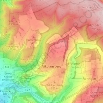
Name: Nikolausberg topographic map, elevation, terrain.
Average elevation: 304 m
Minimum elevation: 164 m
Maximum elevation: 401 m
Make a donation
Gear up for your next adventure:
As an Amazon Associate, this site earns from qualifying purchases at no extra cost to you.
Other topographic maps
Click on a map to view its topography, its elevation and its terrain.
Stadtwald Göttingen und Kerstlingeröder Feld
Deutschland > Niedersachsen > Landkreis Göttingen > Göttingen
Average elevation: 340 m
Astrid-Lindgren-Schule
Deutschland > Niedersachsen > Landkreis Göttingen > Göttingen
Average elevation: 173 m
Make a donation
Gear up for your next adventure:
As an Amazon Associate, this site earns from qualifying purchases at no extra cost to you.
Breslauer Straße 1
Deutschland > Niedersachsen > Landkreis Göttingen > Göttingen
Average elevation: 199 m