Geolocate

Burgos topographic map

Click on the map to display elevation.

About this map

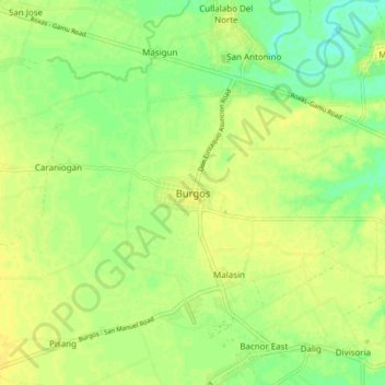
Name: Burgos topographic map, elevation, terrain.

Location: Burgos, Isabela, Cagayan Valley, Philippines (17.02782 121.65360 17.10782 121.73360)

Average elevation: 51 m

Minimum elevation: 38 m

Maximum elevation: 58 m

Other topographic maps

Click on a map to view its topography, its elevation and its terrain.

Magat Dam

Philippines > Isabela

Average elevation: 176 m

San Guillermo

Philippines > Isabela

Average elevation: 92 m

Gear up for your next adventure:

🥾Hiking Shoes - Durable and comfortable shoes for trail hiking
🩹Moleskin Blister Pads - Direct protection for painful foot pressure points
🧦Hiking Liner Socks - Thin base layer to prevent friction and blisters
🧢Outdoor Cap - Protective cap for sun and rain during hikes
🥾Lightweight Hiking Shoes - Comfortable shoes for day hikes

As an Amazon Associate, this site earns from qualifying purchases at no extra cost to you.