Geolocate

Didam topographic map

Click on the map to display elevation.

About this map

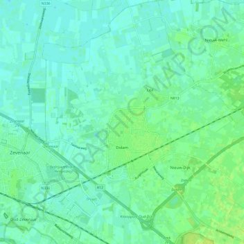
Name: Didam topographic map, elevation, terrain.

Location: Didam, Montferland, Gelderland, Netherlands (51.90887 6.08951 51.98052 6.19332)

Average elevation: 12 m

Minimum elevation: 7 m

Maximum elevation: 21 m

Other topographic maps

Click on a map to view its topography, its elevation and its terrain.

Slingeplas

Netherlands > Gelderland > Bredevoort

Average elevation: 29 m

Elden

Netherlands > Gelderland > Arnhem

Average elevation: 11 m

Arnhem

Netherlands > Gelderland > Arnhem

Average elevation: 24 m

Veldhoek

Netherlands > Gelderland

Average elevation: 18 m

Zwin

Netherlands > Gelderland > Bern > Bern

Average elevation: 3 m

Ubbergen

Netherlands > Gelderland > Ubbergen > Ubbergen

Average elevation: 32 m

Gear up for your next adventure:

🔥Emergency Fire Starter - Reliable ignition source for all weather conditions
🧭GPS Handheld Device - Reliable GPS navigation for outdoor adventures
🧭Orienteering Kit - Tools for map reading and navigation in the wild
💧Hydration Pack - Hands-free hydration system for long hikes
🧴Sunscreen SPF - Broad-spectrum sunscreen for outdoor activities

As an Amazon Associate, this site earns from qualifying purchases at no extra cost to you.