
Make a donation
Gear up for your next adventure:
As an Amazon Associate, this site earns from qualifying purchases at no extra cost to you.
Jouix topographic map
Click on the map to display elevation.
Make a donation
Gear up for your next adventure:
As an Amazon Associate, this site earns from qualifying purchases at no extra cost to you.
About this map
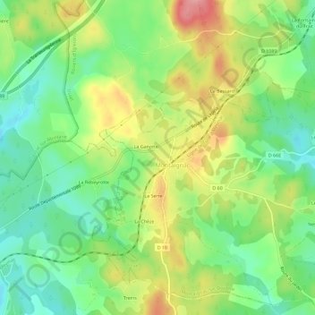
Name: Jouix topographic map, elevation, terrain.
Average elevation: 596 m
Minimum elevation: 548 m
Maximum elevation: 665 m
Make a donation
Gear up for your next adventure:
As an Amazon Associate, this site earns from qualifying purchases at no extra cost to you.
Other topographic maps
Click on a map to view its topography, its elevation and its terrain.
Montaignac-Saint-Hippolyte
France > Nouvelle-Aquitaine > Corrèze > Montaignac-sur-Doustre
Le climat qui caractérise la commune est qualifié, en 2010, de « climat de montagne », selon la typologie des climats de la France qui compte alors huit grands types de climats en métropole. En 2020, la commune ressort du même type de climat dans la classification établie par Météo-France, qui ne…
Average elevation: 590 m