
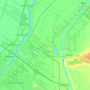
Rural Municipality of East St. Paul topographic map
Interactive map
Click on the map to display elevation.
About this map
Name: Rural Municipality of East St. Paul topographic map, elevation, terrain.
Average elevation: 233 m
Minimum elevation: 221 m
Maximum elevation: 257 m
Other topographic maps
Click on a map to view its topography, its elevation and its terrain.
Libau
Canada > Manitoba > Division No. 13 > Rural Municipality of St. Clements
Libau, Rural Municipality of St. Clements, Division No. 13, Manitoba, Canada
Average elevation: 223 m
Clandeboye
Canada > Manitoba > Division No. 13
Clandeboye, Rural Municipality of St. Andrews, Division No. 13, Manitoba, R0C 0P0, Canada
Average elevation: 226 m
East Selkirk
Canada > Manitoba > Division No. 13 > Rural Municipality of St. Clements
East Selkirk, Rural Municipality of St. Clements, Division No. 13, Manitoba, R0E 0M0, Canada
Average elevation: 227 m
Lockport
Canada > Manitoba > Division No. 13 > Rural Municipality of St. Andrews
Lockport, Rural Municipality of St. Andrews, Division No. 13, Manitoba, R1A 3H6, Canada
Average elevation: 232 m
Selkirk
Canada > Manitoba > Division No. 13
Selkirk, Division No. 13, Manitoba, Canada
Average elevation: 227 m