
Bakonysárkány topographic map
Interactive map
Click on the map to display elevation.
About this map
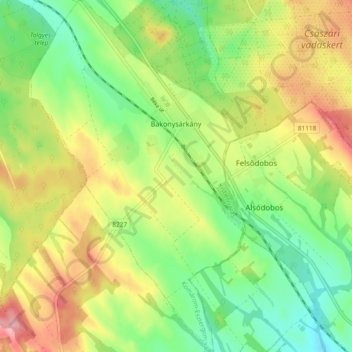
Name: Bakonysárkány topographic map, elevation, terrain.
Average elevation: 233 m
Minimum elevation: 183 m
Maximum elevation: 297 m
Other topographic maps
Click on a map to view its topography, its elevation and its terrain.
Pilismarót
Pilismarót, Esztergomi járás, Komárom-Esztergom, Central Transdanubia, Transdanubia, 2028, Hungary
Average elevation: 289 m
Tatabánya
Tatabánya, Tatabányai járás, Komárom-Esztergom, Central Transdanubia, Transdanubia, Hungary
Average elevation: 229 m
Tata
Hungary > Komárom-Esztergom > Tata > Tata
Tata, Tatai járás, Komárom-Esztergom, Central Transdanubia, Transdanubia, 2890, Hungary
Average elevation: 147 m
Bokod
Bokod, Oroszlányi járás, Komárom-Esztergom, Central Transdanubia, Transdanubia, 2855, Hungary
Average elevation: 210 m
Esztergom
Hungary > Komárom-Esztergom > Esztergom
Esztergom, Esztergomi járás, Komárom-Esztergom, Central Transdanubia, Transdanubia, Hungary
Average elevation: 184 m