Geolocate

Ridgeway topographic map

Click on the map to display elevation.

About this map

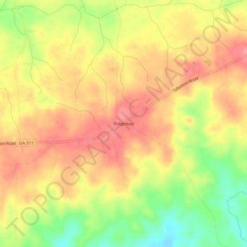
Name: Ridgeway topographic map, elevation, terrain.

Location: Ridgeway, Harris County, Georgia, 31831, United States (32.61541 -84.74159 32.65541 -84.70159)

Average elevation: 206 m

Minimum elevation: 153 m

Maximum elevation: 240 m

Other topographic maps

Click on a map to view its topography, its elevation and its terrain.

Hamilton

United States > Georgia > Harris County

Average elevation: 247 m

Shiloh

United States > Georgia > Harris County

Average elevation: 264 m

Waverly Hall

United States > Georgia > Harris County

Average elevation: 217 m

Whitesville

United States > Georgia > Harris County

Average elevation: 208 m

Pine Mountain

United States > Georgia > Harris County

Average elevation: 274 m

Gear up for your next adventure:

Lightweight Camping Tent - Portable shelter optimized for Canadian backcountry camping
🧢Hiking Sun Hat - Wide-brimmed protection for exposed mountain ridges
🥾Trail Hiking Socks - Comfortable socks to prevent blisters and fatigue
🧭Orienteering Kit - Tools for map reading and navigation in the wild
🚲Bike Repair Kit - Essential tools for on-trail mechanical issues

As an Amazon Associate, this site earns from qualifying purchases at no extra cost to you.