Geolocate

Riel topographic map

Click on the map to display elevation.

About this map

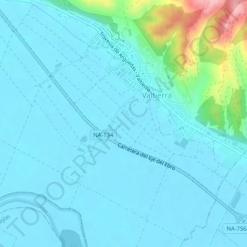
Name: Riel topographic map, elevation, terrain.

Location: Riel, Valtierra, Ribera, 31514, España (42.18031 -1.64660 42.20031 -1.62660)

Average elevation: 279 m

Minimum elevation: 258 m

Maximum elevation: 415 m

Gear up for your next adventure:

🥾Waterproof Trail Shoes - Shoes designed to handle wet terrain
🧴Insect Repellent - Protect yourself from bugs during outdoor adventures
🧤Insulated Winter Gloves - Heavy-duty protection for sub-zero Canadian adventures
💡Solar Camping Lamp - Eco-friendly lighting for campsites
🧥Insulated Jacket - Keep warm in cold outdoor conditions

As an Amazon Associate, this site earns from qualifying purchases at no extra cost to you.