Geolocate

Cairo topographic map

Click on the map to display elevation.

About this map

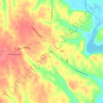
Name: Cairo topographic map, elevation, terrain.

Location: Cairo, Limestone County, Alabama, United States (34.85064 -87.16446 34.89064 -87.12446)

Average elevation: 214 m

Minimum elevation: 169 m

Maximum elevation: 246 m

Other topographic maps

Click on a map to view its topography, its elevation and its terrain.

Athens

United States > Alabama > Limestone County

Average elevation: 204 m

Elkmont

United States > Alabama > Limestone County

Average elevation: 249 m

Elkmont

United States > Alabama > Limestone County

Average elevation: 249 m

Athens

United States > Alabama > Limestone County

Average elevation: 204 m

Gear up for your next adventure:

🛌Insulated Sleeping Pad - Critical thermal barrier between you and the cold ground
🧼Travel Hand Sanitizer - Keep hands clean when water is scarce
Camping Coffee Maker - Brew fresh coffee anywhere on the topographic map
💧Hydration Bladder - Hands-free hydration solution for long treks
🚲Heavy Duty Bike Lock - Secure your bike at the trailhead or during stops

As an Amazon Associate, this site earns from qualifying purchases at no extra cost to you.