
Thank you for supporting this site ❤️
Make a donation
Make a donation
Gear up for your next adventure:
As an Amazon Associate, this site earns from qualifying purchases at no extra cost to you.
Kindelbrück topographic map
Click on the map to display elevation.
Thank you for supporting this site ❤️
Make a donation
Make a donation
Gear up for your next adventure:
As an Amazon Associate, this site earns from qualifying purchases at no extra cost to you.
About this map
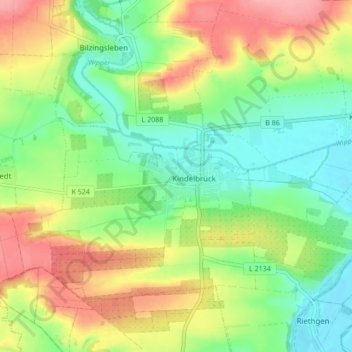
Name: Kindelbrück topographic map, elevation, terrain.
Location: Kindelbrück, Landkreis Sömmerda, Thüringen, Deutschland (51.24272 11.05344 51.28021 11.13882)
Average elevation: 172 m
Minimum elevation: 129 m
Maximum elevation: 232 m
Thank you for supporting this site ❤️
Make a donation
Make a donation
Gear up for your next adventure:
As an Amazon Associate, this site earns from qualifying purchases at no extra cost to you.