Geolocate

Dixie topographic map

Click on the map to display elevation.

About this map

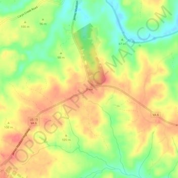
Name: Dixie topographic map, elevation, terrain.

Location: Dixie, Fluvanna County, Virginia, 23055, United States (37.76153 -78.25556 37.80153 -78.21556)

Average elevation: 95 m

Minimum elevation: 60 m

Maximum elevation: 123 m

Other topographic maps

Click on a map to view its topography, its elevation and its terrain.

Columbia

United States > Virginia > Fluvanna County

Average elevation: 78 m

Gear up for your next adventure:

💧Hydration Bladder - Hands-free hydration solution for long treks
🕶️Polarized Sunglasses - Protect your eyes with durable polarized lenses
🥾Trekking Boots - Durable boots for long-distance trekking
🦌Outdoor Trail Camera - Monitor wildlife activity near your favorite spots
🛰️Satellite Messenger - Emergency communication for areas with no cell service

As an Amazon Associate, this site earns from qualifying purchases at no extra cost to you.