
Make a donation
Gear up for your next adventure:
As an Amazon Associate, this site earns from qualifying purchases at no extra cost to you.
Teigny topographic map
Click on the map to display elevation.
Make a donation
Gear up for your next adventure:
As an Amazon Associate, this site earns from qualifying purchases at no extra cost to you.
About this map
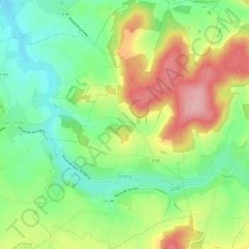
Name: Teigny topographic map, elevation, terrain.
Average elevation: 253 m
Minimum elevation: 188 m
Maximum elevation: 342 m
Make a donation
Gear up for your next adventure:
As an Amazon Associate, this site earns from qualifying purchases at no extra cost to you.
Other topographic maps
Click on a map to view its topography, its elevation and its terrain.
Cheintre Ribaud
Frankrijk > Bourgondië-Franche-Comté > Nièvre > Arleuf > Les Petits
Average elevation: 577 m
Make a donation
Gear up for your next adventure:
As an Amazon Associate, this site earns from qualifying purchases at no extra cost to you.
Crot Manigot
Frankrijk > Bourgondië-Franche-Comté > Nièvre > Moulins-Engilbert > Margoulet
Average elevation: 338 m
Montsaunin
Frankrijk > Bourgondië-Franche-Comté > Nièvre > Château-Chinon (Campagne)
Average elevation: 520 m
Make a donation
Gear up for your next adventure:
As an Amazon Associate, this site earns from qualifying purchases at no extra cost to you.
Petit Lac de Pannecière
Frankrijk > Bourgondië-Franche-Comté > Nièvre > Montigny-en-Morvan > L'Huis André
Average elevation: 322 m
Château de Villars
Frankrijk > Bourgondië-Franche-Comté > Nièvre > Saint-Parize-le-Châtel
Average elevation: 196 m
Make a donation
Gear up for your next adventure:
As an Amazon Associate, this site earns from qualifying purchases at no extra cost to you.
Make a donation
Gear up for your next adventure:
As an Amazon Associate, this site earns from qualifying purchases at no extra cost to you.
Montelesme
Frankrijk > Bourgondië-Franche-Comté > Nièvre > Montsauche-les-Settons
Average elevation: 591 m
Make a donation
Gear up for your next adventure:
As an Amazon Associate, this site earns from qualifying purchases at no extra cost to you.
Chéron
Frankrijk > Bourgondië-Franche-Comté > Nièvre > Saint-Parize-le-Châtel
Average elevation: 217 m
Make a donation
Gear up for your next adventure:
As an Amazon Associate, this site earns from qualifying purchases at no extra cost to you.
Make a donation
Gear up for your next adventure:
As an Amazon Associate, this site earns from qualifying purchases at no extra cost to you.
La Foret
Frankrijk > Bourgondië-Franche-Comté > Nièvre > Villapourçon > Le Croyot
Average elevation: 431 m