
Make a donation
Gear up for your next adventure:
As an Amazon Associate, this site earns from qualifying purchases at no extra cost to you.
Ribérac topographic map
Click on the map to display elevation.
Make a donation
Gear up for your next adventure:
As an Amazon Associate, this site earns from qualifying purchases at no extra cost to you.
Ribérac
Ribérac is on the left bank of the Dronne. To the north, the soil in the Dronne valley is covered with alluvium, while the heights are made up of Cretaceous limestones. Its minimum altitude, 54 meters, is located in the extreme north-west of the town, where a small arm of the Dronne leaves the town.
Make a donation
Gear up for your next adventure:
As an Amazon Associate, this site earns from qualifying purchases at no extra cost to you.
About this map
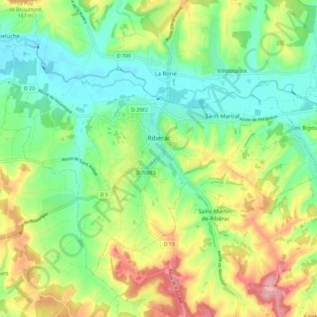
Name: Ribérac topographic map, elevation, terrain.
Average elevation: 107 m
Minimum elevation: 53 m
Maximum elevation: 198 m
Make a donation
Gear up for your next adventure:
As an Amazon Associate, this site earns from qualifying purchases at no extra cost to you.