
Thank you for supporting this site ❤️
Make a donation
Make a donation
Gear up for your next adventure:
As an Amazon Associate, this site earns from qualifying purchases at no extra cost to you.
Old Manali topographic map
Click on the map to display elevation.
Thank you for supporting this site ❤️
Make a donation
Make a donation
Gear up for your next adventure:
As an Amazon Associate, this site earns from qualifying purchases at no extra cost to you.
About this map
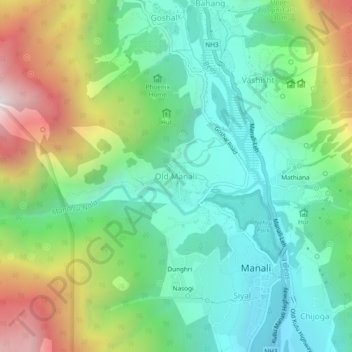
Name: Old Manali topographic map, elevation, terrain.
Location: Old Manali, Manali, Kullu, Himachal Pradesh, 175131, India (32.23593 77.15653 32.27593 77.19653)
Average elevation: 2,290 m
Minimum elevation: 1,845 m
Maximum elevation: 3,213 m
Thank you for supporting this site ❤️
Make a donation
Make a donation
Gear up for your next adventure:
As an Amazon Associate, this site earns from qualifying purchases at no extra cost to you.